Press release -
Sussex and Hertfordshire stations mapped for blind and partially sighted passengers
- GTR installs new and updated RNIB tactile maps at Brighton, Haywards Heath, Three Bridges and Stevenage
- Updates are part of annual £700,000 investment to make 33 stations more accessible (list in editor's notes)
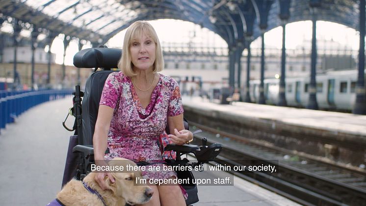
Blind and partially sighted passengers will find it easier to navigate four of the busiest stations in Sussex and Hertfordshire now that Southern, Thameslink and Great Northern have installed RNIB tactile maps.
The update, by parent company Govia Thameslink Railway (GTR), completes an annual £700,000 investment at 33 stations, making small but important improvements based on customer feedback as part of its journey towards making services more accessible.
Elsewhere, stairs have been refurbished with bright white and yellow strips that help partially sighted people see the edges and know when they’re at the top or bottom. Public address systems have been updated to be clearer, new accessibility information points have been created, clearer platform information displays installed and help points updated. See editor’s notes for a full stations list.
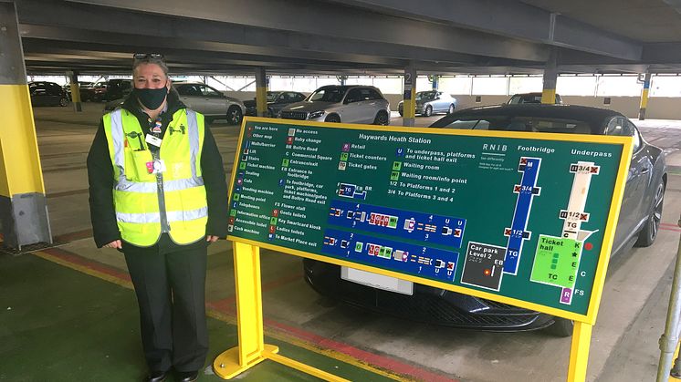
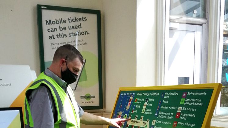
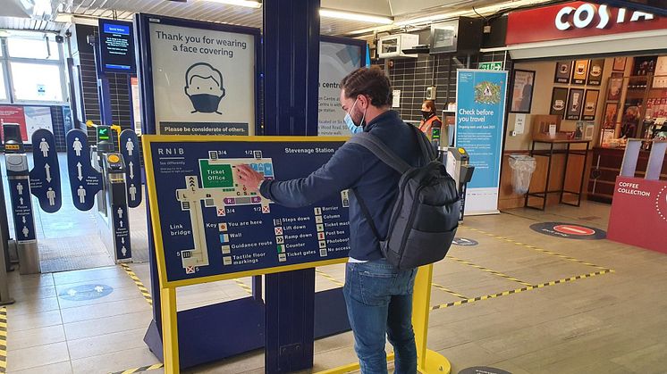
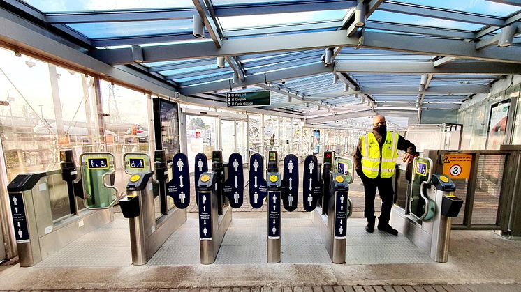
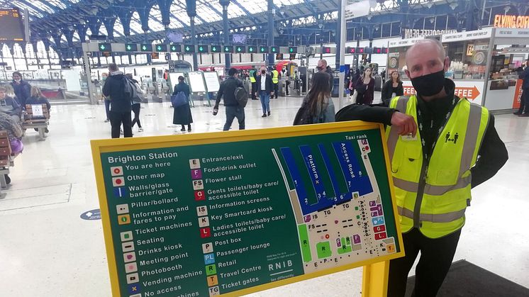
The two new tactile maps at Brighton and Three Bridges, which also has an extra gate wide enough for wheelchair users, parents with buggies and those with luggage, each reflect recent changes in the station layouts. The same is true at Haywards Heath where there’s also an extra map next to its second entrance. Stevenage station now also has an additional tactile map in the main concourse.
Manufactured by the Royal National Institute of Blind People (RNIB), the raised lines and symbols mean the maps can be used by blind and partially sighted passengers. There are also braille translations of printed information.
Michelle Lee, RNIB Accessible Maps, Images and Signage Consultant, said: “RNIB has campaigned over a number of years to make rail travel more accessible for blind and partially sighted people. A fundamental part of this work is ensuring the accessibility of train stations and the support people need to get around them.
“We commend Govia Thameslink Railway for helping with this work by installing ‘RNIB Maps for All’ at four of its stations. These maps will help people with sight loss to travel independently and with confidence.”
Chris Fowler Customer Services Director for Southern, said: “We’re listening and delivering on our pledge to make travelling easier for our disabled customers, and others with accessibility needs. These smart RNIB maps and other small but important improvements made at stations should make a real difference.”
Rail and Accessibility Minister Chris Heaton-Harris said: “I’m pleased to see GTR bring in this important initiative, benefiting blind and partially sighted passengers as people return to our railways.
“I am determined to ensure the rail network is open to everyone, and these maps will ensure passengers can travel with confidence through some of Sussex and Hertfordshire’s busiest stations.”
ends
Notes to editors
Stations to have benefited from the £700,000 investment in the past 12 months:
Alexandra Palace New help point
Brighton Update of tactile maps
Cricklewood New help point
City Thameslink New wayfinding signs
Coulsdon South Stairs enhancement
Crawley Ramp enhancement
Crofton Park Side entrance path enhancement
East Croydon Electric wheelchair
Elephant & Castle Stairs enhancement
Essex Road Better public address
Gordon Hill New help point
Goring by Sea Stairs enhancement
Harpenden Accessible toilet built
Hatfield Improved public address system
Haywards Heath Update of tactile maps
Hendon New help point
Highbury & Islington Improved public address system
Hitchin Better platform info screens
Huntingdon Improved public address system; extra seating
Letchworth Better platform info screens; improved public address system
Moorgate Improved public address system
New Barnet New help point
Norbury Electric wheelchair
Old Street Improved public address system
Potters Bar Grippier surface on station ramps
Radlett Improved public address system
Royston Better platform info screen; improved public address system
Shoreham by Sea Stairs enhancement
Stevenage Update of tactile maps; improved public address system
Three Bridges New ticket gate wide enough for wheelchairs, buggies and people with luggage
Welwyn Garden City New wayfinding signs
Welwyn North Extra seating
Worthing Stairs enhancement
About the RNIB’s ‘Maps for All’
RNIB Maps for All are static maps that can be read by sight, by touch or sight and touch together. They consist of two elements - a map showing the information and a comprehensive explanatory key.
Each map is designed very carefully to combine both visual and tactile elements, resulting in an "access for all" map that is a mix of layers, colours with good visual contrast, textures, large print (which is also raised), braille lettering, tactile and visual symbols.
People with sight problems often have difficulty in following the layout of large areas or buildings. They find it hard to work out where things are in relation to each other and to form an overview of what is on offer. RNIB Maps for All help to overcome these issues by providing the basic information needed to understand the area or building being visited.
The new ‘RNIB Maps For All’ at GTR stations are made of an improved acrylic material with a hard-wearing finish, resistant to fingerprints and easy to clean. The maps typically measure around 1.3 x 0.7 metres, although sizes vary from station to station.
Find out more about the Royal National Institute for Blind People here.
About GTR’s wider station improvement programme
GTR’s network-wide, multimillion-pound improvement programme involves over 1,000 projects, many of which were suggested by local passenger and community groups, at more than 250 stations. While we’re working hard to achieve the punctuality and reliability our passengers rightly expect, we want them to know we are with them all the way and making their stations better places to pass through.
The vast number and range of improvements can be described under three themes:
1. Giving many stations a better ambience by redecorating, planting and installing artwork, often with substantial input from the local community
2. Making stations work better for passengers, improving comfort and safety with new waiting rooms and shelters, seating, lighting, information screens, defibrillators for public use, and accessibility schemes
3. Making stations more sustainable, with schemes such as electric vehicle charging points, secure facilities for cyclists, rainwater retention systems, and even bee gardens.
We’ve created dedicated web pages where passengers and local communities can get updates on what’s happening at their station. They can be found at:
Topics
Categories
For more information, contact the press office on 0203 750 2031.
Govia Thameslink Railway
Govia Thameslink Railway (GTR) operates Thameslink, Great Northern, Southern and Gatwick Express services as follows:
- Thameslink – cross-London services between Bedford/Peterborough/Cambridge and Brighton/Horsham/Littlehampton/East Grinstead, and between Luton/St Albans and Sutton/Wimbledon/Rainham; plus services between London and Sevenoaks
- Great Northern – services between London and Welwyn, Hertford, Peterborough, Cambridge and King’s Lynn
- Southern – services between London and the Sussex coast (Brighton, Worthing, Eastbourne, Bognor Regis, Hastings) and parts of Surrey, Kent and Hampshire (Ashford International, Southampton, Portsmouth)
- Gatwick Express – fast, non-stop direct services between Gatwick Airport and London Victoria
www.southernrailway.com, www.thameslinkrailway.com, www.gatwickexpress.com, www.greatnorthernrail.com