Press release -
Giant trail map promotes North Downs discovery by rail and foot
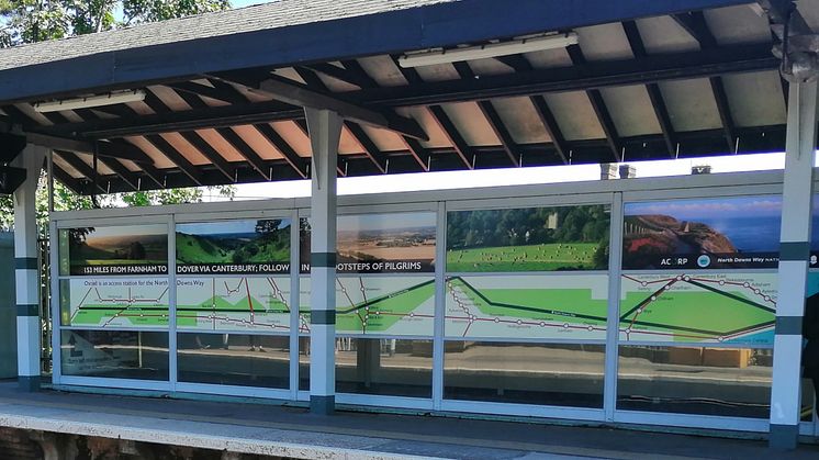
Passengers using Oxted station are having their heads turned by a huge installation promoting the North Downs Way, the National Trail that runs just north of Oxted between Surrey and the south Kent coast. The platform’s glass entrance porch has been transformed with a huge, colourful 13-square-metre display promoting the 153-mile public Trail and railway stations that give access along its route between Farnham and Dover.
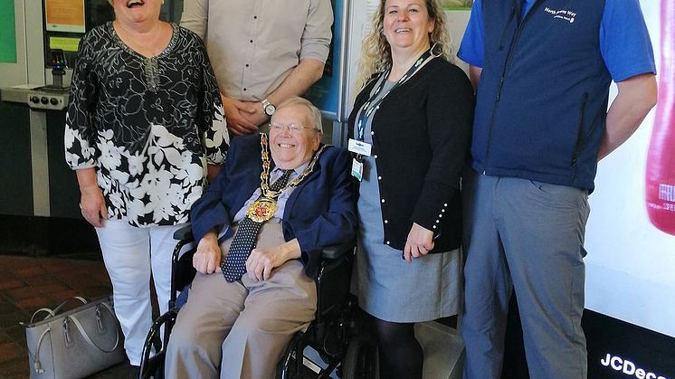
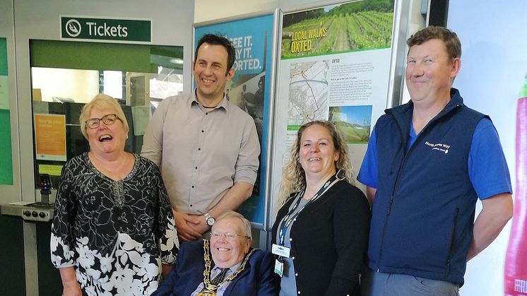
The display was launched officially today [21 May] by Cllr David Cooley, Chairman of Tandridge District Council and Cllr Liz Parker, representing Oxted Parish Council, with North Downs Way Trail Manager Peter Morris and artist Graham Upton, the display’s designer.
Some months ago, Peter Morris asked the Sussex Community Rail Partnership (CRP) if they could work with him on a project to promote a ‘hop on, hop off’ way to walk the trail in manageable sections by using the rail network. Rail company Southern agreed to help, and produced a series of posters that have been installed at their stations giving directions to the Trail. The project has also spread out across Great Western Railway stations in partnership with the North Downs CRP and the national association of CRPs (ACoRP).
Sussex CRP had already completed various planting and artwork projects at Oxted station and saw an opportunity to go big and bold. The large glass porch that covers the entrance to platform 2 offered a fantastic showcase to support the installation, which can be viewed from both platforms.
ACoRP asked award-winning artist Graham Upton to lead the design, and with information provided by Peter Morris and Sussex CRP he set about creating an easy-to-follow map of the Trail, inspired by the London Underground map. He also spent time photographing various locations along the trail to use in his design. ACoRP were approached and asked to support the project, which they generously funded.
Peter Morris said: “We’re really pleased that Oxted has chosen to use the trail map to decorate the platform. It gives users a sense of how far the trail runs and how easy it can be to jump on a train for a great day out. We can’t thank Sharon Gray at Sussex CRP enough for pursuing the permissions and funding to get this project across the line. We hope it remains an inspiration for people to explore the trail for years to come.
“We have worked with rail operators and Community Rail partnerships along the trail, installing information boards at stations showing people how to access the trail and what to see locally as well as additional info on return travel via the rail network. We hope this work encourages more people to get out into the countryside, using the trail as the primary walking route, and of course allowing more people to enjoy the local attractions, food and drink along the way.
“In the future we aim to sign link routes to and from the trail between stations and also hold a series of led walks from stations for people who aren’t familiar with country walking.”
Sharon Gray, Sussex CRP’s line officer, secured the use of the station and organised the installation. She said: “Working on this project with the North Downs Way National Trail and Southern gave us the opportunity to involve some of the small rural stations by installing Southern’s cleverly designed local maps. These show access to the trail, encouraging ‘hop-on, hop-off’ walkers. We were also able to give Oxted station - the largest station with access to the trail - a huge burst of colour with this eye-catching display. I would especially like to thank Southern’s Michelle Nelson who worked so hard on getting the rural station posters designed and completed.”
Southern’s Station Manager Donna Anderson said: "Even while the artwork was being installed passengers were stopping on the platform to admire it, and people passing through on their train have seen it through the windows and asked about it at their home stations. It has certainly attracted a lot of positive attention and comment, and a lot of detailed local interest in the North Downs Way. It's great to promote walking too - we all have a part to play in encouraging healthier lifestyles.”
ends
Note to editors
The North Downs Way is one of only 15 designated National Trails in England and Wales. Passing through 153 miles of stunning and diverse landscapes and through the protected landscapes of the Surrey Hills Area of Outstanding Natural Beauty (AONB) and the Kent Downs AONB, the North Downs Way makes for a great place for a family day out, a short walk or ride, a really good ice cream or a life-changing long distance walk. The North Downs Way is one of the most accessible National Trails in the UK with over 35 railway stations located on, or nearby the trail. The North Downs Way provides tranquillity from the daily grind; lying just south of London and the urban populations of South East England it is the most accessible of the National Trails lying outside of the Greater London borders. With visitor attractions and country parks dotted along the route there are plenty of reasons to escape stress and noise of modern urban living. Users can walk a short section or use the trail to link between towns and villages or take a country walk around a specific place of interest.
Topics
Govia Thameslink Railway
Govia Thameslink Railway (GTR) operates Thameslink, Great Northern, Southern and Gatwick Express services as follows:
- Thameslink – cross-London services between Bedford/Peterborough/Cambridge and Brighton/Horsham/Littlehampton/East Grinstead, and between Luton/St Albans and Sutton/Wimbledon/Rainham; plus services between London and Sevenoaks
- Great Northern – services between London and Welwyn, Hertford, Peterborough, Cambridge and King’s Lynn
- Southern – services between London and the Sussex coast (Brighton, Worthing, Eastbourne, Bognor Regis, Hastings) and parts of Surrey, Kent and Hampshire (Ashford International, Southampton, Portsmouth)
- Gatwick Express – fast, non-stop direct services between Gatwick Airport and London Victoria
www.southernrailway.com, www.thameslinkrailway.com, www.gatwickexpress.com, www.greatnorthernrail.com